Strategies to Combat Flooding:
Gutters and downspouts: If water seeps into the basement when it rains, be sure cutters and downspouts are directing water away from the home. Use downspout extenders to direct water away from your home, check gutters and downspouts periodically to make sure they aren't clogged by leaves or seeds.
Landscaping: If water flows downhill into your home from a driveway or street, a landscaping re-route may be needed to direct the water around your home. Landscaping features could include a dry stream bed, a contoured berm of soil, or a series of raingardens with directed overflow outlets to capture and redirect the water. Be careful not to redirect water into neighbor's homes. Contact VLAWMO for a free on-site visit to discuss needs and possibilities for your property. Projects that solve flooding issues while also providing a public water quality benefit may be eligible under VLAWMO's cost-share program.
Sump pumps: When surficial groundwater levels are very high, groundwater will seep into basements. This happens most often in areas that are landlocked, have heavy clay soils, or are located near wetlands and lakes. The only remedy to groundwater seepage is to use a sump pump to pump water out of the basement and direct it downhill, away from the home.
Temporary protection: If you live near a lowland, wetland, lake, or stream, consider building temporary levees around doors and window wells to protect your home from flooding.
Flooded lawns: As soon as the lawn is dry (this could take several weeks), aerate with a core-type aerifier with several passes in a checkerboard pattern. Repeat process in early September and again the following spring. Break up aerification cores with a lawn or power rake. Overseed after aerating, or target a good time for seeding between mid-August and mid-September. Visit the U of M's resources for repairing flooded lawns or renovating a lawn.
Flood insurance: Be informed of flood insurance policies and be aware that insurance does not go into effect until 30 days after purchase. Visit the FEMA flood insurance program for more information.
Septic systems: If your septic system is flooded, you must stop using it until floodwaters recede and the soil has drained. If you have a pump tank, disconnect the circuit that controls the pump to avoid risk of electrical hazard. Avoid digging around the septic tank or driving heavy equipment over the drainfield while the soil is water-logged. Before flooding, cover drains with a sheet and sandbag to prevent floodwaters from rising up into your home. Visit the EPA website for what to do with a septic system after a flood.
Private wells: Visit the MN Department of Health for recommended steps to take in the case of flooded wells.
Climate Change in Minnesota:
Wet years and strong storms can raise questions about how our region relates to the big picture of climate change in Minnesota. The Minnesota Climatology office refers to observed data to track both trends and cycles in climate. Minnesota's climate is generally showing signs of becoming "less cold" (particularly in winters), seeing more precipitation (accounting for drought years), and greater wet/dry variability. VLAWMO invited Pete Boulay from the Minnesota Climatology Office to interpret the data and trends on Minnesota's changing climate. Click here for a video of the presentation.
State and County Data:
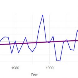
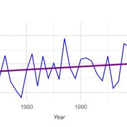
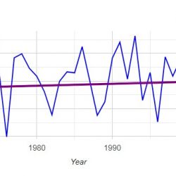
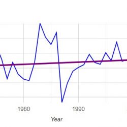
The following graphs were created from the Minnesota Office of Climatology using the publicly available Past Climate Data Retrieval tool. According to staff at the climatology office, an upward trend in State precipitation is seen starting in 1986. VLAWMO staff used the climate data tool to generate Ramsey County graphs centered on this year, starting at 1948. This captured 38 years before and after 1986, ending in 2024. Graphs can also be customized to target other timespans.
The following graphs are divided into the summer growing season (May-Sept) season and the winter (Oct-April) season. This aligns with VLAWMO's water monitoring program, which collects precipitation data along with lake quality data from May to September. Other data available from the tool includes temperature and drought severity.
What Can We Do About Climate Change and High Water?
- Help improve storage on the landscape. Do you know of spaces in parking lots or yards that are more or less "dead" filler space? Chances are these spaces contain opportunities for storing water instead of running it off the surface. Raingardens, native plantings, retention basins, and other stormwater best management practices (BMP's) help reduce stormwater runoff volume. These help prepare for large rain events and mitigate downstream flooding. Through partnerships, VLAWMO is able to utilize grant programs and a network of expertise to put projects in the ground - but we can't do it alone! Connect with your local parks commission, city council, local businesses, or VLAWMO to express interest and learn about the resources that are available. VLAWMO hosts annual workshops to help homeowners and businesses participate.
- Join the discussion. Cities, counties, and watersheds such as VLAWMO work together to solve problems like local flooding and drainage. In many cases, infrastructure such as culverts and outlets require upgrading to accommodate for larger rain events and more water. Such projects require feasibility studies, meetings, and detailed plans, and typically include windows for public comment. Studies and support are also needed in wetland restoration efforts, which seek to maximize wetland function and storage.
- Explore resources that are available. Check out the resources in the drop-down menu below to review data records, learn about the implications of climate change, and create your own custom graphs and charts. Visit the VLAWMO GIS site for an interactive look at water levels, wetland boundaries, and local topography.


